The Celandine Route is located in the borough of Hillingdon in west London, and it follows the River Pinn from Hayes through Ruislip and then finishes at Pinner. There is a twelve-mile walkway through meadows, parks, and woodlands along the river from end to end. The route is named after the Lesser Celandine, a yellow flowering woodland plant that thrives in wooded shade. The walk can be completed in six hours, but I only walked a part of the route from Eastcote House to Pinner. I walked the route in the middle of January.

I started at Eastcote House, which I previously wrote about here: Eastcote House at Christmas. Eastcote House has become a favourite local place of mine that I have been visiting once every couple of weeks during this difficult time. Although the house no longer remains, the stables, cafe, walled gardens, and flower beds remain and are cared for by community volunteers.

I enjoy sitting in the walled garden and having a bite to eat for lunch. In early January, this little robin stood next to me during my visit, and it chirped away happily.


The River Pinn is located just below Eastcote House on the slope downward to plains where visitors can cross the river and muddy turf on a walkway and wooden bridge.

I visited since my walk, and the river was much higher. We have been getting a lot of rain and snow.


Along the route, information boards explain the route and what different types of plants and animals can be seen along it. Each area is also marked as a route. At the bottom of Eastcote House is a large flood plain that takes several minutes to walk. Part of the walk is paved, but most of it is not. The large amount of people and dogs that walk the route mean that it is very muddy in places.

Some of the first signs of spring were noticed on my visit at the end of January with these purple crocuses.

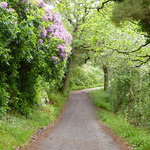
The walk is a pleasant one, and I enjoyed this part of the walk the best with its large trees and open area. However, it was so muddy in a couple of places, and that was not at all enjoyable.


There is a small bridge near part of the walkway, if you wish to walk close to the river. It was so muddy. I did not walk through it.

Crossing a narrow road meant that I was on the other side of this flood plain and met with another and more narrow plain with large houses on both sides. The river bent around and changed direction here, and this was probably the muddiest bit, even muddier than the picture with the bridge in this post. There was no way to avoid the mud.

A couple of photos below show the worst area with the mud, and the other photographs show the entrance to the wooded area entrance.


Here at the wooded area is a part of the trail that leads off to the main roads and housing estates in Eastcote or Pinner. The Celandine Route is marked on the map. A bridge links one of the housing estates with the route.


The wooded area was less muddy because the trees soak up the water. The walkways were defined through the trees and follows the river closely.

There was one muddy patch, but it was not too bad.

The below photograph shows how close the trail is to the river, and this is probably the closest that it has even gotten to the river.

Foamy dirt settles on top of the river where it funnels around a turn in the forest. There are houses on both sides with one side having the woods back onto the properties.


At the other side of the wooded area and before we say goodbye to the river, there are community allotments along the path.

The house at the very end of the trail, before the gate to exit the wooded walkway, has a view over the river and a large decking area. I thought it was a cafe.

The Celandine Route heads to Pinner Memorial Park, but I had a little walk to Pinner Village Gardens, which is a large garden area that was laid out in the 1930s, according to the signs. It's a bit hibernating at the moment due to the cold winter months, but I can see how this would be an attractive spot. There are little gardens set out amongst the grounds and play areas for children.


At the other end of the gardens is Marsh Road, which leads to Pinner underground station and the main street with cafes and shops. I did not wander to the High Street, which is an attractive place, due to running out of time. I did not want to walk through the park land and grounds alone in the dark.

The actual Celandine Route ends at Pinner Memorial Park. There is a museum here to visit, and I will visit it once it reopens. The museum is the Heath Robinson museum, and he was an illustrator for books and a cartoonist.

I walked briskly back to Eastcote House Gardens, and if approaching from the Pinner direction, Eastcote House is in front and across the bridge. The building seen is the dovecote, and you can also see the walls of the walled garden.

I'll leave you with a sunny photograph of Eastcote House.

I think that the route is probably very muddy in the winter and autumn months where there is more rain. I hope to walk the route again soon, although walking in the mud is not the most enjoyable of activities. I hope to visit during the different seasons to spot some of the plants and animals and enjoy what the local area has to offer. I would also recommend if you are not local to the area once the restrictions are lifted.


Leave a comment